About
With years of experience, our team of experts specialize in providing actionable data for surveyors, architects, and property maintenance professionals. We understand the unique challenges these industries face, which is why our drone services deliver accurate and detailed information to streamline operations and enhance decision-making processes.
What sets us apart from our competitors is our commitment to quality and precision. Our state-of-the-art drone technology coupled with our skilled operators enables us to capture high-resolution imagery and data that meet the highest industry standards. We take pride in our ability to provide comprehensive inspection reports, 3D mapping, and detailed surveys, equipping our clients with the information they need to make informed choices and optimize their projects.
Services
Capture high-resolution images and videos of buildings for accurate condition inspections and progress monitoring.
Obtain detailed and precise topographic maps to assist in site planning and design.
Detect insulation problems, water leaks, and structural issues with thermal imaging services.
Track and document construction progress with regular aerial photographs and videos.
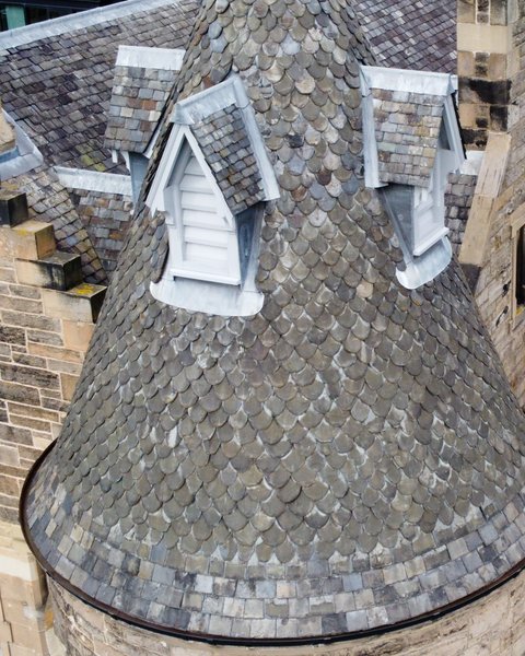
Our team of experienced professionals leverages advanced drone technology to provide accurate and detailed assessments of buildings at various heights. Whether you are a building surveyor, an architect or property maintenance professional, our surveys will assist you in making informed decisions and creating effective plans for maintenance, repair, or renovation projects. Trust us to deliver reliable and comprehensive data to support your building assessments and ensure optimal results for your clients.
Identify potential hazards and safety risks with aerial inspections of construction sites.
At Construction Drone Services, we offer comprehensive building condition surveys for building surveyors and architects. Our team utilizes state-of-the-art drone technology to inspect building facades for defects and condition. By providing detailed and accurate assessments, we help our clients make informed decisions for maintenance, repairs, and renovations. Trust Construction Drone Services for efficient and reliable assessment of building facades to ensure safe and structurally sound structures.
At Construction Drone Services, we offer an innovative solution for building surveyors and architects - creating 3D models with drones. Our cutting-edge technology allows us to capture detailed aerial imagery and transform it into accurate, high-resolution models. This revolutionary approach enhances the accuracy and efficiency of building condition surveys, providing our clients with a comprehensive understanding of the structure's condition. Experience the power of 3D models and revolutionize your building surveys with Construction Drone Services.
Why work with us

Our team of highly skilled and experienced drone pilots are experts in navigating construction sites, capturing footage, and delivering accurate data for your project.
With our state-of-the-art drones and advanced software, we can quickly collect comprehensive data on your construction site, reducing manual labor and saving time.
We prioritize safety in every aspect of our operations. Our drones are equipped with advanced sensors and GPS technology, ensuring precise and reliable data collection without any risk to workers or the site.
Projects
Our Team
Harnessing years of aerial data expertise, our team comprises top-notch professionals dedicated to providing unmatched commercial drone services to the construction industry.
All of our drone operators hold current General Visual Line of Sight (GVC) certification from the UK Civil Aviation Authority (CAA).
Testimonials
' fill='%23d2ea9b' fill-rule='nonzero'%3e%3cg id='img-quote' transform='translate(934.000000%2c 1405.000000)'%3e%3cpath d='M27%2c0 C12.0810811%2c0 0%2c12.0629685 0%2c26.9595202 C0%2c31.4122939 1.05405405%2c35.6221889 3%2c39.3463268 L0%2c54 L14.5945946%2c51.0044978 C18.3243243%2c52.9475262 22.5405405%2c54 27%2c54 C41.9189189%2c54 54%2c41.9370315 54%2c27.0404798 C54%2c11.982009 41.9189189%2c0 27%2c0 Z M27%2c52.2188906 C22.9459459%2c52.2188906 19.0540541%2c51.2473763 15.4864865%2c49.3853073 L14.9189189%2c49.0614693 L14.3513514%2c49.1424288 L2.35135135%2c51.5712144 L4.78378378%2c39.6701649 L4.86486486%2c39.1034483 L4.54054054%2c38.5367316 C2.67567568%2c34.8935532 1.7027027%2c31.0074963 1.7027027%2c26.9595202 C1.7027027%2c13.0344828 12.972973%2c1.78067842 26.9189189%2c1.78067842 C40.8648649%2c1.70014993 52.1355699%2c13.0344828 52.1355699%2c26.9595202 C52.2162162%2c40.8845577 40.9459459%2c52.2188906 27%2c52.2188906 Z' id='Shape'/%3e%3cg id='Group' transform='translate(18.000000%2c 20.000000)'%3e%3cpath d='M8%2c1.65745856 C7.11111111%2c2.15469613 6.46464646%2c2.56906077 5.8989899%2c2.98342541 C5.41414141%2c3.31491713 4.84848485%2c3.8121547 4.28282828%2c4.39226519 C3.7979798%2c4.88950276 3.39393939%2c5.46961326 3.15151515%2c6.13259669 C2.90909091%2c6.71270718 2.66666667%2c7.54143646 2.58585859%2c8.5359116 L3.87878788%2c8.5359116 C5.01010101%2c8.5359116 5.8989899%2c8.78453039 6.54545455%2c9.36464088 C7.19191919%2c9.94475138 7.51515152%2c10.7734807 7.51515152%2c11.8508287 C7.51515152%2c12.5966851 7.19191919%2c13.3425414 6.62626263%2c14.0055249 C6.06060606%2c14.6685083 5.25252525%2c15 4.28282828%2c15 C2.74747475%2c15 1.61616162%2c14.5027624 0.96969697%2c13.4254144 C0.323232323%2c12.3480663 0%2c11.0220994 0%2c9.28176796 C0%2c8.03867403 0.242424242%2c6.96132597 0.727272727%2c5.96685083 C1.21212121%2c4.97237569 1.85858586%2c4.06077348 2.58585859%2c3.31491713 C3.31313131%2c2.48618785 4.12121212%2c1.82320442 4.92929293%2c1.32596685 C5.73737374%2c0.745856354 6.46464646%2c0.331491713 7.03030303%2c0 L8%2c1.65745856 Z' id='Shape'/%3e%3cpath d='M19%2c1.58333333 C18.1111111%2c2.08333333 17.4646465%2c2.5 16.8989899%2c2.91666667 C16.4141414%2c3.25 15.8484848%2c3.75 15.2828283%2c4.33333333 C14.7979798%2c4.83333333 14.3939394%2c5.41666667 14.1515152%2c6.08333333 C13.9090909%2c6.66666667 13.6666667%2c7.5 13.5858586%2c8.5 L14.8787879%2c8.5 C16.010101%2c8.5 16.8989899%2c8.75 17.5454545%2c9.33333333 C18.1919192%2c9.91666667 18.5151515%2c10.75 18.5151515%2c11.8333333 C18.5151515%2c12.5833333 18.1919192%2c13.3333333 17.6262626%2c14 C17.0606061%2c14.6666667 16.2525253%2c15 15.2828283%2c15 C13.7474747%2c15 12.6161616%2c14.5 11.969697%2c13.4166667 C11.3232323%2c12.3333333 11%2c11 11%2c9.25 C11%2c8 11.2424242%2c6.91666667 11.7272727%2c5.91666667 C12.2121212%2c5 12.7777778%2c4.16666667 13.5050505%2c3.33333333 C14.2323232%2c2.5 15.040404%2c1.83333333 15.8484848%2c1.33333333 C16.6565657%2c0.75 17.3838384%2c0.333333333 17.9494949%2c0 L19%2c1.58333333 Z' id='Shape'/%3e%3c/g%3e%3c/g%3e%3c/g%3e%3c/g%3e%3c/svg%3e)
Iain and his team at Construction Drone Services have always provided a professional and response service. The information provided from the surveys is of a good quality. Iain works to ensure the client brief and objectives are always delivered.
― Hamish Paterson
Director of Building Surveying
Thomas & Adamson
The service Construction Drone Services provides is second to none. They take time to understand my exact requirements for the job and captures detailed, high-quality imagery. The team is efficient and personable. Their Risk assessments are always detailed and they obtain all necessary consents ahead of time to ensure the job is completed on time. I would recommend Construction Drone Services to anyone looking to obtain a drone survey.”
― Chyrelle Watt
Building Surveyor
Colliers
Why use us?
Why Choose Construction Drone Services?
- Cutting-edge technology: We use state-of-the-art drones equipped with high-resolution cameras and thermal imaging capabilities to conduct building condition surveys with unmatched precision.
- Time and cost-efficient: Our drone surveys eliminate the need for traditional methods such as scaffolding and manual inspections, saving you both time and money.
- Expert team: Our experienced professionals ensure that you receive high quality data enabling you to make informed decisions about your building projects.

Contact
We are here to assist you. Give us a call and let our team answer your questions and address your concerns.
Drones and Privacy
People are quite rightly concerned that drones, or as they are otherwise known, Unmanned Aerial Systems (UAS), may be used to take film or photographs of them or their property without their permission. As professional drone operators, ensuring privacy is a top priority. At Construction Drone Services, we understand the importance of maintaining privacy while conducting building condition surveys with drones. We adhere to strict ethical guidelines and legal regulations, ensuring that all data collected is used solely for the purpose of surveying and inspection.
We respect the privacy of individuals and property owners at all times. Our experienced drone operators are trained to prioritise privacy by avoiding areas where privacy could be compromised. Additionally, we take necessary precautions to protect the data collected during the surveys. With Construction Drone Services, you can trust that your clients' privacy is being respected while still benefiting from the speed, accuracy, and efficiency that drone technology brings to building condition surveys. Rest assured, our services prioritise privacy and professionalism to provide you with the best results.
We are registered with the Information Commissioner's Office and abide by their code of practice.
If you think you may have been inadvertently filmed, please get in touch with us and we will investigate and delete any identifiable images we have of you.
Protecting Vulnerable Groups (PVG) and Disclosure and Barring Service (DBS)
For further peace of mind, we hold Enhanced PVG and DBS certificates to reassure our clients that we have been vetted by Police and can work with children and vulnerable adults. You can therefore be reassured when we are conducting drone operations in residential areas, near or in schools and student accommodation.


